PLANNING CONSTRAINT MAPPING
Planning constraint services show you the optimal areas for development and help you to select a development site. Selecting the optimal site is crucial for project success, and my detailed assessments ensure you have the necessary information to make informed decisions.
Comprehensive Evaluations:
Choosing the right site involves considering a variety of constraints and factors. My planning constraint mapping services offer thorough evaluations of each potential location, providing a clear comparison to identify the best option for your needs.
Key Features of CONSTRAINT MAPS:
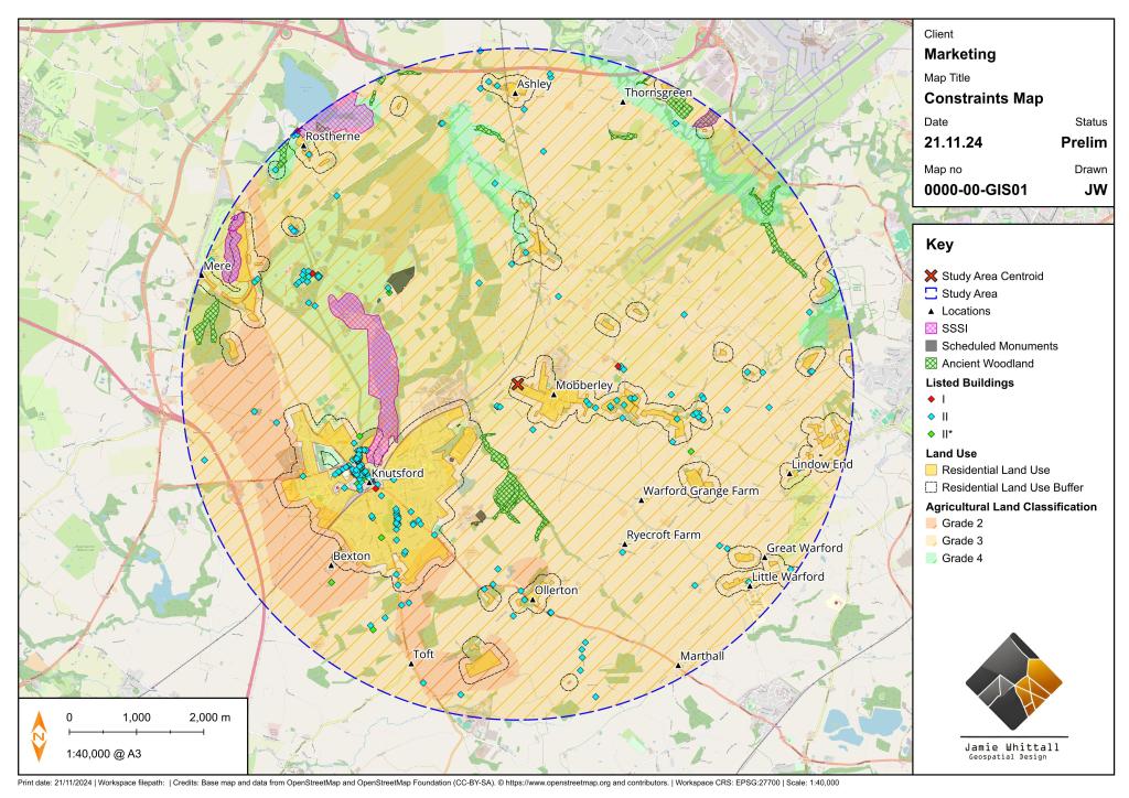
- Environmental Constraints: Assess environmental barriers, including ecological constraints, flooding risks, and slope / gradient issues.
- Historic Assets: Identify and evaluate historic assets on or near the site to minimise impact on cultural landmarks.
- Agricultural Land Classification: Analyse the agricultural land classification to determine the suitability of land for development, avoiding prime agricultural land.
- Planning Compliance: Ensure each site complies with national planning policies, avoiding planning obstacles.
- Infrastructure and Amenities: Examine the availability of essential infrastructure and amenities, such as utilities, schools, healthcare, and retail, to determine how well each site supports future development.
Why Choose Alternative Site Assessment Services?
- Detailed Insights: I provide comprehensive mapping with in-depth analysis, offering clear and actionable insights to guide your decision-making process.
- Client-Focused Approach: I work closely with you to understand your specific needs and objectives, tailoring the assessments to provide the most relevant and valuable information.
- Innovative Tools and Techniques: Utilising advanced GIS technology and spatial analysis methods, I deliver unique and tailored GIS constraint mapping solutions.
CLIENT FEEDBACK – WALSINGHAM PLANNING
I’m thrilled to have worked with planning professionals at Walsingham Planning during my ‘Introduction to QGIS’ course. It’s inspiring to see planners taking the initiative to deepen their technical skills and broaden the role of GIS in their projects.
“The course has aided in creating constraints maps, particularly in a heritage setting.”
“Thank you again for delivering the training, I found it very useful, and the content was spot on for what I think we need GIS to do.”
Constraint mapping is a vital tool for informed decision-making, whether in heritage settings or wider planning projects. With GIS, planners can visualise and analyse data more effectively, ensuring their designs respect constraints while unlocking the full potential of their sites.
Supporting Your Development Goals
My planning constraint mapping services are designed to support your development goals by providing the critical information needed to choose the best possible site. Whether you are planning a residential, commercial, or industrial development, my planning constraint assessments help you find the optimal location.
By leveraging my expertise, you can ensure that your project is positioned for success from the very beginning. I help you identify the strengths and weaknesses of each potential site, giving you the data to make informed decisions.
